| Busts and monuments of distinguished men in
national history and science, such as Simón Botivar, Teodoro
Gómez de la Torre, Pedro Moncayo, etc.
The snow topped montain of Cayernbe which can be
seen southeast of the city. Visit traditional places in the city (esquina
de coca - the coconut tree comer and San Juan Calle among others).
You can also enjoy listnening to and admiring the music
and folklore of Irnbaburian groups which play in differen lodging locations
in the city and province.
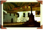
In Caranqui remain several vestiges of what was
the big Templo al Sol and the Hacienda La Victoria where
royalist and conservative forces fought in the Battle of Ibarra led by
Sirnón Bolivar.
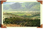
Go for a walk to the Mirador of Nuracruz in order
to take in the panoramic view of the city which is organized in a grid
shape next to the Yahuarcocha laguna.
In Caranqui (2 Km. from Ibarra) archeological artifacts
of the Palacio del Sol the birthplace of Atahualpa (son of the Shyrian
Princess Paccha and the Inca Huayna capac) and the iglesia del Señor
del Amor (a church).
| Avenida de El Retorno (5 Krn.) and
the town of La Esperanza - where inhabitants of nearby areas fled
after the 1868 earthquake which devastated the province. The town even
maintains its old buildings. Past La Esperanza are the tolas de Zuleta
(ritual burial mounds of ancient peoples) (18 Km.) panoramic views from
the Cunrru hills where you can see Ibarra and its surroundings.
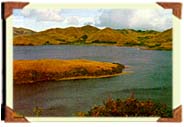
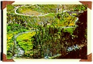
The Cunrru and San Pablo Lakes (38 Km.) are separated by areas overabundant
in wheat fields and pine trees until the descent into Otavalo. Continue
the route to the three Majanda lagunas: Caricocha,
Guarmicocha and Yanacocha (17 Km.) from Otavalo. |
|
 |
Go through the Zuleta
Hacienda (18 Km.), a colonial house of the former President
of Ecuador, Galo Plaza Lasso. It has been converted into an artisian
center (traditional embroideries) without having stopped the regular agricultural
activities. |
Begin, from Zuleta, excursions to el Cunrru (3,304
meters) and el Cubilche (3836 meters), small elevations with woods
and lagunas converted into strategic natural look out points. Take the
Zuteta-Pesillo Cayambe route, with landscapes of plateaus and planted lands
you will enjoy.
Travel around the lago San Pablo (a lake) (38 Km
taking this route) visiting indigenous communities which occupy the land
of the ancient peoples. The indigeneous inhabitants worship the mountain
they call "Taita Imbabura". Practice water sports or attend the swimming
competition which takes place every year in September during the fiesta
del Yamor (the Yamor fair).
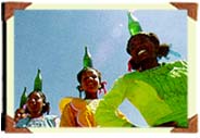
Participate in the fiesta de San Juan (the San
Juan fair) (June 24) which evokes the ancestral Anti Raymia;
or the fiesta del sol (celebration of the sun) with old rituals
that still remain.
Travel down to Pucará Rey Loma (a hill next
to the San Pablo Lake) which in addition to being archeological remains
I in the fonm of terraces will also permit you to see the whole surrounding
valley.
Continue on the second class road which first connects
Otavalo with the three lakes of Mojanda where you can stay to
fish; then further on you will arrive in the province of Pichincha where
after visiting the Tolas de Cochasqui (burial mownds) (30 Krn.)
you can regain the Panamerican Highway in Tabucundo.
Leaving from Zuleta if you follow the cobblestones road
to Pesillo you can both take a small side trip to see and fish in
the San Marcos Laguna and also travel to Cayambe in the Pinchincha
Province.
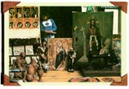
Otavalo; if artensanship is to your liking the
route offers both artistic works and natural attractions.
Visit the towns which continue to apply ancestral techniques
in their artesanship using natural products: San Antonio de Ibarra
(6 Km.) -wood carvings and stone sculptures; Tanguarin (7 Km.) -
clay objects; San Roque (18.6 Km.) - looms for cabuya (a fine string)
and wool where the entire artensanship process is shown; llumán
(24 Km.) - felt hats; Carabuela (23 Km.) material of callúa
(a natural fiber) and handicrafts in wool; Cotacachi - artisans
of leather; Peguche - looms and wool handicrafts; Otavalo
wool handicrafts; San Juan Pogyo -baskets made of straw; and Huaycopungo
artisanship in totoras (a dried plant).
These centers account for the artisanship production of
the majority of indigenous communities of the area.
Visit the towns of San Roque and Peguche where
there is a waterfall of the same name flowing through woods o eucalyputus
trees and plants used in neutral medicines. Thi is one of the indigerieous
ceremonial sites where the San Juan Festival (June 24th) is started.
Visit the cities which have been converted into the core
of tourist and economic activities in the province.
Atuntaqui; the industrial city of the province
is located 125 Km. southwest of Ibarra.
Cotacachi; from here you can see the Cotacachi
volcano and its foolhitIs where the city was established. The iglesia matriz
of Santa Ana (the citys principal church) where special rituals
are celebrated for the Semana Santa (Saints Week) in April or May. With
your camera you can also capture a panoramic view of Ibarra.
Go into the artesian shops where you can buy handicrafts
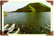
and other goods made of leather. Take the road that leads you to Cuicocha
the only lake in Ibarra formed by a crater. You can take a boat trip which
crosses the Canal del Ensucho going between the islotas (small islands)
of Teodoro Wolf and Yerovi.
If you like walks take the Gorky Campuzano path
which circles the lake (four hours of walking). The path also has information
about the lake engraved in stones.
 |
Another altemative is to climb to the peak
of the Cotachi volcano or to take an excursion to the
Piñan lagunas (Donoso Susacocha etc.) enjoying the
green landscape while fishing and choosing angles for your photographs.
Cotacachi can also be the starting point of an adventure to the area of
Intag (go Km.) which you should not miss. |
| Intag Valley; investigate the biodiversity
of the preserved woods La Florida walk up to natural look out points or
visit Guatimám a strategic ceremonial pre-incan site which has pyramid
shaped totes (burial mounds) with access ramps. You can also see archeological
vestiges which are part of the smell archeological museum established here.
Enjoy a thermal bath in Nanguivi or fish in the Rio
Cristopamba (a river) and its tributaries. Observe the processing
of cabuva. |
|
 |
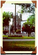
Otavalo;
old builings such as the Concejo Municipal (municipal Building)
and the convento and iglesia de El Jordan (a convent and church)
which has a facade of polyangular Incan origin. |
Gruta del Socavón (a grotto) where the
image of the Monsenat Virgin, next to a peaceful spring, is worshipped
by many people.
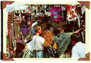 |
Go through the Plaza
El Centenario, known as "EI Mercado de Ponchos" where
you can shop for handicrafts of the region and the country, especially. |
Take a walk to Pucará Rey Loma a hill
and old fortress where a legendary milk giving tree is located and also
a center of indigenous rituals and ceremonies. You also get a view of San
Pablo lake in the foothills of Imbabura Mountain and the city of Otavalo.
Organize an excursion to the cascade de Peguche a waterfall
where you will find picnic and recreation areas.
Observe the creation of handicrafts in nearby communities
such as Punyaro (zwo · straw handicrafts) and Huaycopwngo
(esteras - handicrafts of a dried plant). |