GUAYAS 


(3k) ecotourism 

 (1k) Sol 
(2k) ViaEcuador 
Approved by: 
(3k) Cetur
Visite nuestro HomePage
 
 
(2k) Onnet 
All Rights Reserved by OnNet
Any requirement please
communicate to webmaster@onnet-ec.com 
tourism - ecuador - travel - galapagos - ecotourism - via ecuador - coast - guayaquil - tourism - ecuador - travel - galapagos - ecotourism - via ecuador - coast - guayaquil - tourism - ecuador - travel - galapagos - ecotourism - via ecuador - coast - guayaquil -  
(12k) Welcome to Guayaquil 

Guayaquil, the Pearl of the Pacific, is a city of two million inhabitants and the economic capital of Ecuador, an honor it has earned thanks to its untiring commercial activity which has been the leading force its progress since the beginning of the century. 

Guayaquil and its surroundings invite the tourists to tour the city and visit pleasing sites, a contrast between old and new where they will find a large selection of crafts and manufactured products in general. 

The Cerro del Carmen and Santa Ana, hilltops from where you have a view of the city and of the convergence of the Daule and Babahoyo rivers which together form the Guayas River. The Bridge of National Unity is the largest in country, crossing the Daule and Babahoyo river 

At the top of the Cerro del Carmen, you will find the Monument to the Sacred Heart of Jesus blessing the city and at the foot of it the General Cemetary, also called "The White City" . It is considered the most beautiful in America because of the large number and the quality of its sculptures, it has more than 80 monuments made of Carrara marble imported directly from Italy. (3k) Monument to the Sacred Heart of Jesus
 The "Barrio las Peñas" located at the foot of the Santa Ana hill is an area of the city with a coastal colonial architecture. During the festivities conmemorating the foundation of the city, this area becomes the sites of outdoor exhibitions where national as well as foreign artists expose their works. Today many of the house along this street have been turned into art galleries. 

The Church of Santo Domingo, was tthe first church of this city. The Basilica de la Merced, San Francisco and the Metropolitan Cathedral should also be visited. 

The Malecon Simon Bolivar, which runs along the River, is also called "El Paseo de las Colonias". The Public Clock (Moorish Tower), Municipal Palace (City Hall) of neoclassic style is considered one of the best architectonic works of the city, The "Hemiciclo de la Rotonda" where a great marble and bronze statue is erected, conmemorating the meeting between two great liberators in America: Simón Bolivar and San Martin. (6K) Hemiciclo de la Rotonda
 The Botanical Garden is located at the foot of the Cerro Colorado hill at Avenida Francisco de Orellana. Here you can find three thousand varieties of vegetable species including hundred and fifty varieties of orchids.  

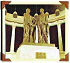
If you like excursions, we should like recommend a visit to Cerro Blanco. Situated on Km. 15 on the coast road it is a representative sample of tropical dry forest and constitutes an important refuge for more than hundred and ninety species of land birds and six species of sea birds. 

(4k) Column of October of Liberty 
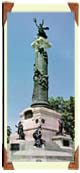
Parque Centenario a beautiful park in the middle of the city, in the center of which stands the Column of October of Liberty. 
 
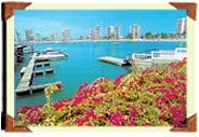
The Centro Civico Theater; the Planetarium of the Navy and Puerto Maritimo, one of the most important ports of South America on the Pacific Ocean where ships from all over the world dock.
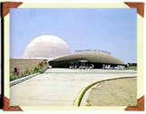
  (5k) Planetarium of the Navy
 In short, Guayaquil, green and tropical, is a port with a bohemian lifestyle, a modern city full of joy and activities, a city which offers the best to its visitors. 
 
 
 Guayas' Beachs 
 
(8k) Salinas 
Salinas 


(4k) Montaņita 
Montañita 


Salinas.- Is a totally urbanized beach, being the first beach of the country, and a place where important beauty contest take place.Located at 1 hour and 40 minutes of Guayaquil. A point that you should not let to visit the Chocolatera, located in the narrow lace edging, constitutes the second geographical point of South America, where two marine currents (Humbolt and El Niño) encounters and produce a clash of waves against the rocks, which causes an unique show. Salinas offers to the national and foreigner tourist all the facilities of lodging, recreation and fun. 

Punta Carnero.- It is an open beach with marked inclination for the sector of cliff toward the south end. It is located at the west of Santa Elena. 

General Villamil (Playas): Located at 64 km from Guayaquil, it is a open beach with a slight constant curve with Northeast direction. In this direction are hills and zones of cliffs as well as old urban density. 

Beach of Ballenita.- It is a beach half closed with sections of discharge and low inclination. It is located in the South-Southwest in form of bay and is a bath with a great urbanized part. 

Beach of Data-Posorja: It is a very picturesque beach, being its main characteristic the presence of hundred of gulls that fly around the fishing ships that are on the bank.  

Beach of Montañita: Located in the town of Manglaralto at 59 Km from Santa Elena, the beach is wide and ideal for surfing competitions. 

Beach of Punta Blanca: The beaches are developed in four sectors due to the presence of rocks are half closed in form of bay lightly inclined. This beach is completely urbanized. 

Playa Rosada: To the North of thick tip and lowering the hills of big Engamel, the direction of the beach goes from North to Northeast, the beaches have a great inclination, favorable for diving.Its name is due to the tonality of the minerals reflection. 

Ayange.- Simply a paradise of beach; in form of a shell, with the water totally transparent. 

Beach of Capaes: It is a beach completely urbanized with the exception of a "parallón" of mountain range. In the beach is a rocky sector of little depth with formation of algae in their surface. The form of the beach is of a Bay half closed with slope. 

Olon beach: It is a beach of soft decline and significant width and extension. The direction of the beach is South Southeast where is formed a valley in the river Mancay , for there appear the mountain range upon leaving from the sea. 

Beach of the Curia: It is an open and clean beach, to the front of the mountain range in parallel to the line of the beach with bushes creating a marine landscape incomparable.  

Beach of San José: This beach is straight, with South-Southeast direction, beach of soft decline, old width, clear sand and end, without rocky zone. The beginning of a natural attractiveness of our beaches that are expressed with old in accordance intensity advances toward the south. 


(5k) Playas 
Playas 


Text and graphs are property of (2k) ViaEcuador