|
Named after Hector Egas,
the owner of an ill-fated salt-mining company during the 1960s, Puerto
Egas carves out a corner of James Bay, on the western end of
the lava coated island of Santiago. Like many commercial ventures
in the Galapagos, this attempt (and its predecessor in the 1 920s)
to extract a profitable mineral from the salt lake crater immediately beyond
the shiny volcanic fields that make up the coast at Puerto Egas was doomed
to failure. Today, a few roads and the remains of abandoned buildings serve
as reminders of these abortive efforts.
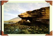
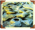
Most visitors to this area of James Bay come to see the
shoreline south of Puerto Egas, with its striated yellow, brown, and black
cliffs of tuffstone, or hardened volcanic ash, which has also been eroded,
molded, and polished by the sea into coves and elaborately patterned rocky
beaches. Hikers on the coastal trail may be privileged to spot whales or
dolphins cruising by offshore or a feeding frenzy of hundreds of boobies
or pelicans attacking a school of fish. At the end of the trail is a magnificent
lava-walled grotto whose shady crevices shelter a small group of fur seals.
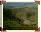
Perhaps the single dominant feature of the Puerto Egas
/ James Bay region is a volcanic cone called
Sugarloaf, which rises almost 1,300 feet. Formed as the
result of the explosive interaction of hot molten rock and cool seawater,
this tuft cone and its 700-foot neighbor to the south produced the sandy
layers of volcanic ash visible in the nearby cliffs. To the north and east
is a large lava flow (noted by Charles Darwin in his journals in 1835),
in which fragments of ceramic pots stashed by buccaneers and dated 1684
were later found establishing an age bracket for this volcanic activity.
The landscape surrounding James Bay is harsh, covered
primarily by a sparse forest of polo Santa trees, which is threatened by
the large population of feral goats on the island who have consumed all
but the most unpalatable and heavily armored of native vegetation. The
land is consequently turning into an open savannah. and a herd of coats
moving across the island calls to mind wildlife on the plains of East Africa.
The National Parks Department hopes to remove most of the goats,
but without adequate funds for doing so on this relatively large islands,
temporary measures, such as fencing off some areas of native palnt life,
must suffice. |