tourism - ecuador
- travel - galapagos - ecotourism - vía ecuador - andes - carchi
- tourism - ecuador - travel - galapagos - ecotourism - vía ecuador
- andes - carchi - tourism - ecuador - travel - galapagos - ecotourism
- vía ecuador - andes - carchi -
|


 Approved by:
 Visite
nuestro HomePage
Visite
nuestro HomePage

 All Rights Reserved by OnNet
Any requirement please
communicate to webmaster@onnet-ec.com
All Rights Reserved by OnNet
Any requirement please
communicate to webmaster@onnet-ec.com
|

Carchi carries the heritage of the Cacique Carcia
Tulcanaza Pupas, brave warriors who, in their heart , always Rosessed
allegiance to the mother country. It is th highest capital of the country
(3001 meters) and has inten commercial activity, especially during the
Thursday market.
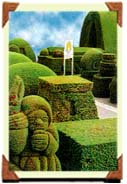
| Visit the Escultura
en Verde del Campo Santo (a topia garden in the cemetery)
in which Cyprus trees have been sculpted into shapes representing
both the flora and fauna Ecuador and also relevant objects from
cultures of th Romans, Greeks, Incas, Aztecs and Egyptians, amen others. |
 |
Visit the Casa de la Cultura Ecuatoriana "Benjamin
Carrion Nucleo Carchi with regional archeological artifacts. Visit
the Museo del Instituto National Bolivar with archeological artifacts
from the area.
Take an excursion to nearby petroglifos (ancient carved
rocks) such as "Piedra Pintada de Chapues".
 |
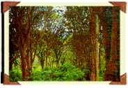
Row a boat in "Las Canoas" where the
Rio Bobo (a river) meanders gently through smooth hills of eucalyptus
trees, pines, and attractive wild flowers. |
Enjoy a thermal bath in Ruminichaca.
See the Iglesia de la Virgen de Las Lajas en Urbina,
a church next to the border of Colombia. Here, you will also find an image
donated by Juan Montalvo, a distinguished Ecuadorian writer.
See old buildings such as the Cathedral, the convento
Capuchino, the Mercado Market, la Cooperativa Pablo Muñoz
Vega, the Teatro Lemarie (the Lemarie Theater), and several private
houses, all with a stylistically eclectic influence.
Ninety-six miles of second-class roads and hundreds of
"chaquiñanes" and paths, will permit you to enjoy tourism
in nature, the discovery of the countryside, professional or amature photography,
hiking, excursions and above all the internal fullfilment of observing
and enjoying nature - to feel and remember it forever. Whatever your route,
in traveling west from Tulcan be prepared for constant changes in altitude
(3001 to 200 meters), in temperature (l0 to 30 degrees centigrade), and
in climate. Also, make yours, this beautiful Carchian area, which is waiting
for you.
The first stretch of the trip is dominated by planted
land and pastures in an infinite gamut of green and yellow through which
you can barely see the fertlie brown earth.
Upon arriving at the town of Tufiño (18Ym.)
and later, on small walks, you can see several of the thermal springs (in
their natural states), giving evidence of the existing mineral richness
(Tufiño, Agualodo, El Achupallal and Aguas Hediondas).
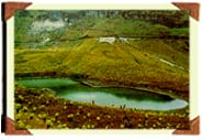 |
Continuing on this route, and after going
around a group of east-west mountains , you come upon the cluster of "Lagunas
Verdes", which reflect the color green from sulphuric waters
of its five small lakes. This vast area of 15,715 Ha. forms the Reserva
Ecologica El Angel with a perdominance of frailejon and paja greminea.
Its is also home to many animals such as deer, bears, pumas, wolves, rabbits,
and others. Several of these, you can see on your trip. |
|
At the 90th Km, you reach the neighboring Maldanado
and Chical valleys, consisting of primary woods and planted crops specially
tropical fruit.
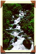
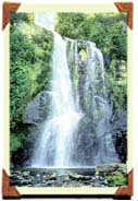
| Next to the road and flowing through vegetation
are las cascades (waterfalls) of La Centella
(57 Km.), La Humeadora (59 Km.), Pulpito (63 Km.) La
Comadre (65 Km.) and Cuaypambi (84 Km.). |
 |
The drivable road ends in Chical (96 Km.) but this
is only the beginning of new choices for seeing the San Juan River
- the international known by Colombia as the Rio Mayasquer (a river).
This scenic river flows into the area named La Bocana (where rivers
meek) giving an interesting formation to the rocks of its interior and
surrounded by a population of butterflies and tropical vegetation; see
the Utepa experimental station and visit the site's historical vestiges
(an old washing place made of indigenous gold, a stone painted by Chical,
and petroglifos (ancient carved rock) of Quinilul).
Enjoy a light bath in the Tufiño hot springs (18
Km) or in the Hedionas Waters (25 Km). (precaution: Excessive use
can be harmful due to the presence of sulphur.) Walk up part of the Chiles
Volcano (4,768 meters) or conquer the top where the landscape is divided
bi-nationally between the principal valleys and elevations of the Northern
Sierra of Ecuador and the Department of Nariho in Colombia.
Find the best angle so that each photograph has the quality
of a post card.
Learn of the site's legends and traditions about the mysterious
disappearances of ancient civilizations. Organize and go on short or long
excursions and investigate the biological species of each ecological floor;
or go fishing.
If you enjoy challenges you can undertake a horse ride
(one day from Chical) in order to visit the Reserva Forestal y Etnica
Awa (the forest and Ethnic Awa Reserve) an area of natural pure woods
and mountains with extrordinary biological diversity, including endangered
species. It is an area geographically shared by the provinces of Carchi
and Esmeraldas in Ecuador, and in Colombia, the Department of Nariho.
It has been converted into the Comunidad Awa and handicrafts are Heated
from natural fibers so that no one will forget their visit. If you decide
to stay in Chical and the culture is to your liking, visit the petroglifos
(ancient carved rocks) of the area and perhaps your theory regarding their
presence and meaning will be the most fundamental.
In the town of Huaca, the Santuario de la Virgen de
la Purificacidn (La Purita) (a sanctuary) attracts hundreds of travelers
especially during its festival in February. There is also an adjoining
archeolo-ical museum which exhibits religious documents containing nformation
about the cultures which inhabited the area. On the shrouding hills are
the protective El Mirador woods, of difficult access, in which one
can examine a strange configuration of human shaped rocks.
 |
The town's surroundings indicate the great
richess in mineral waters and hot springs not even exploited because they
are irmnersed in an excellent agricultural zone (La Calera, Santa Teresita
and various springs next to the Bobo river) . At the 29th Km. you should
take the side road towards the town of Santa
Martha of Cuba so that you can see the remains of the myrtle
tree woods, which contain species hundreds of years old. |
Back on the road, the Panamerican Highway will take
you south, this time towards San Cabriel (42 Km.) and its surroundings.
A city which deserves to be called "Procerato al Trabajo"
for its contribution to the development of the country, it boasts the only
church in Ecuador built in accordance with the "Ley de Indias".
Outside of the principle plaza, it is visible from any point of view.
|
Taking a loop toward the east on the cobblestoned road,
you can visit the myrtle tree Monteverde Woods (8 Km.) and the Laguna
Del Salado, which have a beautiful landscape and variety of birds.
Visit the Cascade de Paluz
(a waterfall) by taking a second crass road surrounded by
planted fields. |
 |
Another possibility in going south is to take the second-class
road which joins Tulcan with the town of El Juntas (3 Km.) continuing
until San Francisco de Huaquer (25 Km.). Starting here, vast plains
and mountains dominate the mountain ranges in which the Andes divide in
Ecuador. Travel through hills covered by frailejon until you arrive at
the woods in San Francisco de Pioter (50 Km.), a natural area rich
in oak trees and plants that both are low on the growled and grow on trees.
Fifteen minutes more leads you to the cascade de San Pedro which
has a double fall creating a ford in the middle, which is visited by many
travelers and those who love to fish. Ten minutes further is the town of
Pioter, rich in oral traditions such as "Los Duendes de Pena Blanch"
or "Los Aparecidos" . Visit the cascade de Pena Blanca which
has strange holes in its side walls. Also, see the small 7 prtrnary woods
where hundreds of small parrots go in certain undefined seasons. The end
of this road connects with the Panamerican Highway, giving you the choice
of attending, in Julio Andrade, a game of handball or pingpong ball, or
going to the town of Huaca.
From San Gabriel, the road will take you to the town of
Bolivar (18 Km.) where thousands of travelers go to visit the santuarios
del Senor de la Buena Esperanza and de la Virgen de la Paz, the
latter of which occupies a natural grotto, containing thermal waters ir1
which you can take a healthy bath.
If you continue south on the Panamerican Highway, you
will descend into the Chota Valley, reaching the town of Piqulucho
(15 Krn.) where the province of Carchi ends. It is suggested that you take
the second-class side road at Tumbatu where you can see the traditional
dwellings of blacks in the middle of tropical fruit ,olantations and also
visit natural lookout points If you choose to continue on the tourist route
south of Carchi you should go towards the west. At the fourth km. is the
laguna La Ecanada and the city of El Angel (11 Km.). Here
is the point of departure to visit the Reserva Ecologica El Angel, where
you will put to test your physical fitness, that is, if you wish to enjoy
Andear1 scenery unmatched by any other. You car1 visit lakes such as Razochoca,
Negras and Hondor1, wealthy in frailejones and wild flowers and where
deer, curiquingues (a type of bird), and condors live. Enjoying all of
this is a walk of five or six hours, which, of course, is worth the excursion!
However, if you prefer to walk for only 30 minutes, your best alternative
is either to go up the 3000 meters and visit the lagunas of Voladero, from
the natural lookout point, or go down towards the water to fish. The decision
is yours!.
Regaining the tourist route which started in Bolivar,
you can visit San Isidro (21 Km.) an area devoted to the cultivation
of wheat and to wool handicraft production. Then, in the Mira (25
Krn.), appropriately named, you can contemplate the view of the vast valley.
Mira is known for the Santuario de la Virgen de la Caridad, artesans
of wool and masapan (a mortar of flour and water used to make flat figures),
and also its famous orange juice based drink, named Tardon Mireho.
A side road will lead you to Rio Blanco where you can visit both
a museum of natural rock (80 Km.) and also the Concepcion where, in April.
and May, you can attend the Semana Santa with Afro Ecuadorian traditional
rituals and ceremonies.
After 40 Km., you will be in the community of Mascarilla
in the Chota Valley. The Chota Valley divides the two nothern Sierran
provinces of Carchi and Imbabura; so the farewell is only a new welcome
this time to the blue region of Ecuador, named as such for its wealth of
lakes.
|
Text and graphs are property of
|